

Hot And Humid Air Returns This Weekend With Storms Possible Sunday
UNDATED (WJON News) -- A warming trend will continue into the weekend, when hot and humid conditions will return in full force.
The National Weather Service has issued a Tornado Watch for Northwestern Minnesota on Friday until 11:00 p.m.

Saturday and Sunday are expected to be the hottest.
There is a Heat Advisory in effect on Saturday from noon until 10:00 p.m. with an Extreme Heat Watch on Sunday afternoon and evening.
Areas just to the south of St. Cloud will be under an Extreme Heat Warning this weekend.
St. Cloud has officially had eight days in the 90s so far this year. We average just over 11 days in the 90s each year.
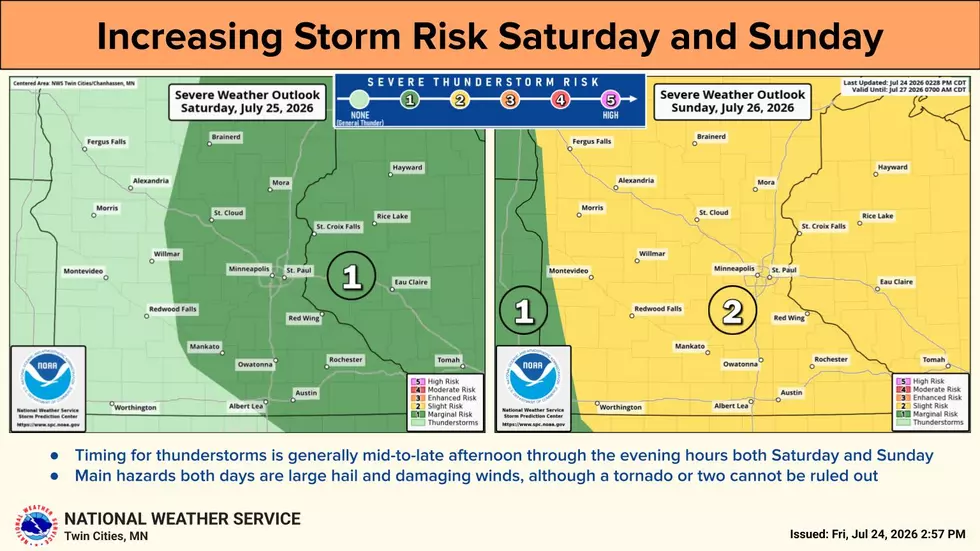
There is growing potential for severe thunderstorms over eastern Minnesota into late Saturday and across all of Minnesota late Sunday. The main hazards are large hail and damaging winds, although a tornado or two cannot be ruled out.
St. Cloud has officially had 2.14 inches of rain so far in June, which is 0.58 of an inch below normal. For the summer months of June and July combined, we've had 5.71 inches of rain, which is 0.71 of an inch below normal.
The latest weekly update from the U.S. Drought Monitor has 87 percent of Minnesota abnormally dry, 48 percent is in a moderate drought, and 17 percent is in a severe drought.
Check out the painted murals of Downtown St. Cloud
Gallery Credit: Jim Maurice, Townsquare Media St. Cloud
More From AM 1240 WJON