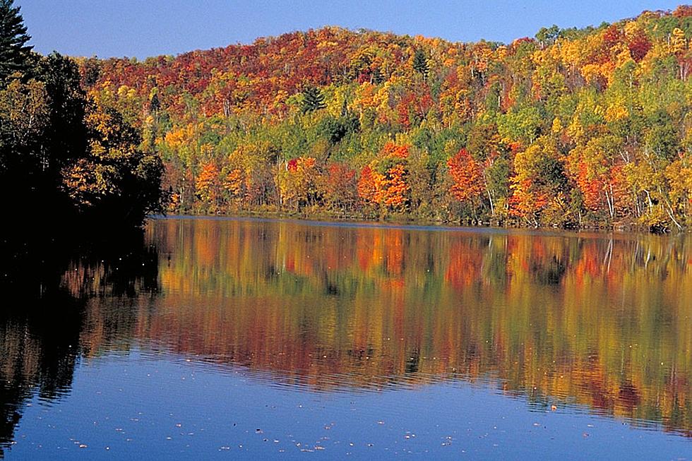
Hit The Road This Fall With Minnesota’s Scenic Byways
Late summer and fall are great times for road trips in Minnesota. Jake Juliot from Explore Minnesota joined me on WJON to highlight some options.
Plan the Perfect Road Trip on Minnesota's Scenic Byways
With so many breathtaking views and unique attractions along the way, road trips on scenic byways will reward you with miles of memorable experiences. With 22 scenic byways stretching almost 3,000 miles across the state, all you must do is pick one and go. Explore these routes by car, or for added thrills, by motorcycle.
Apple Blossom Drive Scenic Byway
This rolling farmland and bluff-top route travels high above the Mississippi River, offering dazzling views of the valley below. Each end of this thoroughfare connects with Highway 61, a.k.a. the Great River Road, another scenic drive.
Avenue of Pines Scenic Byway
Highway 46 stretches from Deer River to Northome. Its outstanding scenic values include views of mature red pine stands, sparkling lakes, marshes, and aspen stands.
Edge of the Wilderness National Scenic Byway
This route was once used by voyageurs and loggers through the Chippewa National Forest, over rolling hills, and past bogs and fishing lakes. Much of the 47-mile drive that connects Grand Rapids to Effie has spectacular scenery, from historic sites and small towns to bald eagles and balsam firs.
Glacial Ridge Trail Scenic Byway
This 220-mile route navigates west central Minnesota. Massive glaciers once covered this land, and as they melted, lakes formed among hills and ridges. This byway offers several scenic loops and side trips and passes by three state parks: Sibley, Monson Lake and Glacial Lake, good spots for hiking, bird watching and fishing.
Great River Road National Scenic Byway
The Great River Road follows the course of the Mississippi River through 10 states. It is an official All-American Road and considered one of the country's premier driving destinations. Minnesota's portion is a network of roadways offering a bounty of river experiences in a parkway setting. It spans 565 miles, 43 communities, 20 counties, three
tribes and six unique destination areas, providing public access to and promoting exploration of America's Great River.
Gunflint Trail National Scenic Byway
Beginning in Grand Marais, a charming harbor town on Lake Superior, this paved road heads inland through the rolling hills of Superior National Forest. There are no towns along the route, but side roads lead to resorts, campgrounds, canoe outfitters and boat ramps.
Highway 75 King of Trails Scenic Byway
Minnesota's King of Trails Scenic Byway is part of Historic Highway 75, a true whopper of a road that travels the entire United States, and extends from Winnipeg to the Gulf of Mexico. The route stretches 414 miles along Minnesota’s western border, and includes such iconic stops as Blue Mounds State Park.
Historic Bluff Country National Scenic Byway
Follow the lush Root River Valley and wind your way through a landscape of woodsy hills and dramatic dolomite bluffs, marked with the tranquil silhouette of a lone Amish buggy. The route passes along the Root River Trail, a popular spot for bikers and paddlers.
Lady Slipper Scenic Byway
Journey through the Chippewa National Forest as you travel the 28-mile Lady Slipper Scenic Byway. Located between Blackduck and US Hwy 2 just east of Cass Lake, it features pine and hardwood forests, lakes, recreation areas, historic sites and crosses the mighty Mississippi. Ladyslippers — Minnesota’s state flower — are a common sight along the byway in late June.
Lake Country Scenic Byway
Approximately 3 ½ hours north of the Twin Cities, the 88-mile Lake Country Scenic drive travels a segment of Minnesota's Pine to Prairie Birding Trail, and connects three "anchor" towns: Walker, Park Rapids and Detroit Lakes.
Lake Mille Lacs Scenic Byway
Spanning 68-miles, this loop gently curves around Lake Mille Lacs, the state’s second-largest inland lake and has long been a popular activity for travelers, especially in the fall.
Grand Rounds Scenic Byway
The Grand Rounds Scenic Byway offers a little bit of everything: great scenery, historic sites, art, outdoor recreation, and shopping and dining, all within the heart of Minneapolis. There are many access streets throughout the city, and views of the skyline are visible from just about every portion of Grand Rounds.
Minnesota River Valley National Scenic Byway
The Minnesota River begins at Big Stone Lake; this drive follows it along a series of roads to Belle Plaine. You’ll find stops in Le Sueur, St. Peter, Mankato and New Ulm along the way.
North Shore All-American Scenic Drive
The spectacular scenery of the North Shore of Superior, including eight state parks, has earned this scenic route a national designation as an "All-American Road." Stop in small shoreline towns like Grand Marais, Lutsen, Two Harbors, and more to find restaurants serving local fish, as well as unique shops and art galleries.
Otter Trail Scenic Byway
Birders love the 150-mile Otter Trail Scenic Byway, which circles a rolling region of more than 1,000 lakes and prairie potholes, where pelicans, herons and swans can be seen nesting and feasting along the shores.
Paul Bunyan Scenic Byway
Named for the tall tale hero, the Paul Bunyan Scenic Byway double loops through the Brainerd Lakes area, starting with County Road 11 as it heads east to Breezy Point and Pelican Lake. The byway heads north through the Crow Wing State Forest to Crosslake, a
charming boutique town and recreation area. Travelers can choose a northern or southern route around the Whitefish Chain of Lakes, a hub for boating, fishing, exploring and staying at classic resorts.
Shooting Star Scenic Byway
This scenic byway is one of the state's first designated wildflower routes. The Minnesota Departments of Transportation and Natural Resources collaborate to manage wildflowers and native grasses along the route. The route passes through small towns with historic buildings, bed and breakfasts, golf courses, and city parks.
Skyline Parkway Scenic Byway
Overlooking Duluth, the Skyline Parkway offers travelers a rewarding, bird's-eye view of the harbor and the endless shoreline of Lake Superior. Recreational opportunities include hiking, cross-country skiing, and mountain biking along the Duluth Traverse Trail.
St. Croix Scenic Byway
The 124-mile St. Croix Scenic Byway runs from Point Douglas near Hastings to a point north of Sandstone. Prepare to be impressed by the rugged beauty of the St. Croix River Valley with long vistas, rolling landscapes, and jagged cliffs
Superior National Forest Scenic Byway
The Superior National Forest drive takes travelers on a relaxing wooded drive from the North Shore to the communities of the Iron Range. Fall color buffs will delight in the spectacular reds and yellows of the hardwoods and towering pines.
Veterans Evergreen Memorial Drive Scenic Byway
This section of Highway 23 has been known as the scenic route to Duluth for decades. Near the beginning is Banning State Park, with camping, hiking, river fishing, canoeing and, for the adventurous, kayaking the Kettle River with its infamous "Hell's Gate" rapids. Near the end of the route is the Veteran's Memorial Overlook, with a breathtaking view of the St. Louis River Valley.
Waters of the Dancing Sky Scenic Byway
Minnesota's northernmost scenic drive travels from Voyageurs National Park along the Canadian border. The route runs along the Rainy River from International Falls to Baudette, through fields of lady's slippers from Baudette to Warroad, and along the Pine to Prairie Birding Trail west of Warroad. The "Dancing Sky" refers to the aurora borealis, or northern lights, which frequently appear in the area thanks to its far-northern location and absence of bright city lights.
Come Visit Rice, Minnesota With Us
More From AM 1240 WJON