Update: Winter Weather Advisory Issued for Tuesday
UNDATED -- The National Weather Service has issued a Winter Weather Advisory from 7:00 a.m. until 7:00 p.m. on Tuesday for Stearns County and areas to the west. The Advisory will be in effect from 10:00 a.m. until 10:00 p.m. for Benton and Sherburne Counties and areas to the east.
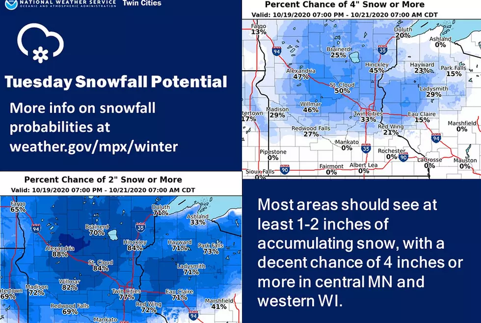
Total accumulations of snow between two and five inches are expected.
Motorists should prepare for snow-covered road conditions in portions of Minnesota beginning Tuesday morning as a winter storm is expected to bring snow to the region through Wednesday morning, which means travel could be difficult.
The Minnesota Department of Transportation encourages motorists to check 511mn.org before they travel to see current road conditions and view highway and snowplow cameras along their route.
They say hundreds of snowplow operators will be working during the winter storm to keep road conditions as safe and clear as possible. Motorists should remember to slow down, stay alert, and stay back at least 10 car lengths and use extra caution when driving near snowplows.
If travel is necessary, the Minnesota Department of Public Safety recommends everyone in the vehicle is dressed for the cold weather. Motorists should keep blankets, water, food, phone chargers and an emergency kit in your vehicle.
There's still uncertainty on where the rain/snow line will set up on Tuesday afternoon, but at least 2 inches of snow is looking quite likely across central Minnesota into northwest Wisconsin, with amounts of 4 or more inches possible.
It will feel and look a lot more like late fall this week, with several chances for rain and even accumulating snow.

Fall Leaves at Saint Cloud State University
More From AM 1240 WJON