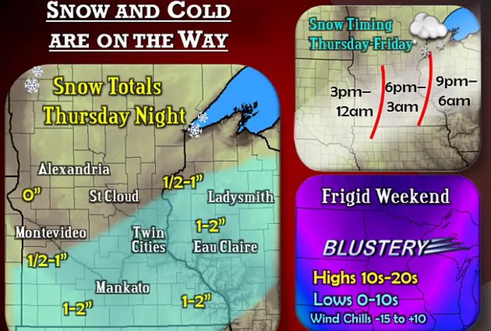
A weather disturbance will move through Thursday night and bring light snow accumulations. This will be followed by very cold air for the weekend as an arctic cold front blows through.
A pleasant weekend is in store for much of the region as high pressure builds in. A large storm system will progress into the region on Monday and persist through at least Wednesday.
We officially had .38" of an inch of rain at the St. Cloud Regional Airport on Wednesday. We collected another .66" yesterday (Thursday). That brings us to a total of 1.04" between the two days combined.
Rainbows and golden filtered sun appeared after thunderstorms rumbled through Central Minnesota last night. Photographer Steven Sohlstrom captured these beautiful shots around 7:30 last night, scrambling his radio controlled camera plane after spotting this intense rainbow.
Hot and humid weather will continue across the region through Thursday with heat indices hitting 95 to 100 degrees Thursday afternoon. A Heat Advisory remains in effect until 9:00 p.m. this (Thursday) evening. Afternoon highs will be in the lower to mid 90s, with heat indices of 100 to 103 degrees.


![Summer Threats to Your Pets [VIDEO]](http://townsquare.media/site/68/files/2013/08/DOG.jpg?w=980&q=75)

![Aerial Camera Captures Intense Rainbow Over St. Cloud Area [PHOTOS]](http://townsquare.media/site/67/files/2013/08/rainbow_aug6-2013_sohlstrom.jpg?w=980&q=75)
