Snowmageddon: Extended Forecast Shows Ridiculous Snow Amounts Across Minnesota
WHAT THE HECK IS A 'COLORADO LOW?"
This week has been interesting, to say the least. Winter has been waiting to release its wrath upon us here in central Minnesota but has decided that now is the time. Mother Nature doesn't want to miss her chance for one last Hurrah!
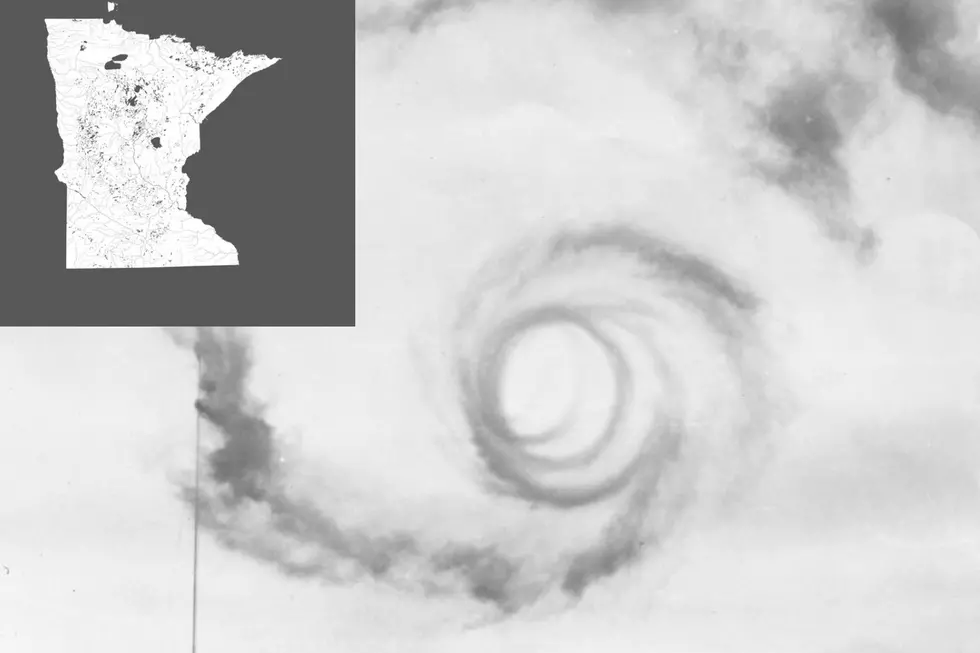
What's happening right now in Minnesota is called a "Colorado Low." (It sounds like a fancy drink, doesn't it?)
ARRIEL'S WEATHER WATCH
A Twin Cities man who studies weather has a Facebook page known as 'Arriel's Weather Watch. He describes himself as a Minnesota weather enthusiast and storm tracker. This is what he had to say on his page, about the pending weather:

"Alrighty, guys, let's chat about what's coming our way in the weather department over the next few days. As our current snow system bids us adieu this afternoon, we can expect some sun to break through those clouds, nudging our highs into the cozy low to mid-30s.
Saturday's looking pretty chilly during the day, with highs bobbing in the upper 20s to low 30s under a sky that'll switch from mostly sunny to mostly cloudy as we head towards evening.
Now, for the main event: Saturday night through Tuesday is when the weather plot thickens. We're eyeing a 'Colorado Low', which is meteorologists speak for a low-pressure system that forms on the lee side of the Rockies. This one's riding a shortwave from the southern US, pulling up a big blanket of warm humid air from the Gulf of Mexico northward thanks to some southerly winds. This system's bringing more of a broad-scale impact than our recent snow banding adventure.
As this 'Colorado Low' tracks across Iowa, we'll see a shift from isentropic ascent (a fancy way of saying warm air rising over cooler air) to deformation banding late Sunday into Monday. Deformation banding is like nature's way of organizing a weather pattern where the atmosphere gets stretched in one direction and compressed in another.
This stretching and squeezing action can create narrow, intense bands of snow that are infamous for dumping heavy snowfall over targeted areas. So, when I say "deformation banding," think of it as the atmosphere setting the stage for potentially significant snowfall to blanket our region, especially as we head into late Sunday and continue through Monday, with the action possibly extending into Tuesday.
Any little jog in the path of this 'low' could majorly shuffle the deck in terms of what type of precipitation we get.
For now, it looks like southern MN might get a rain/snow mix on Sunday afternoon, flipping back to all snow by evening. And yep, blowing snow could get rowdy Sunday into Monday, with gusts possibly toppling over 30 mph.
Temps are on a slight uptick with eastern MN and western WI looking at mid-30s Sunday, then upper 30s to mid-40s by Monday. Because of this mixed bag of precipitation and the strong potential for this system, a Winter Storm Watch is on the books for a good chunk of central and southern MN and western WI from Sunday morning through Tuesday morning.
We're potentially looking at snow totals that could leave us staring at over 12 inches, especially out west in MN. But, with the expected mix of precipitation types, we might see some snow compaction, which could mean the totals end up a tad lower than we might think.
After we navigate through this winter storm, there's a brief pause before we're onto monitoring another system that might spice things up again next weekend. Temps will keep inching up, with daytime highs settling into the 40s and nighttime lows cozying up in the 20s.
Stay tuned, stay prepared, and as always, I'll keep you posted on all the twists and turns in our winter weather saga. Stay warm and safe, everyone!"
Presidential/Vice Presidential Visits to St. Cloud
What Does AI Think St. Cloud Looks Like at Christmas?
More From AM 1240 WJON