Severe Storms May Develop Today
UNDATED -- It is a dry start to this Saturday across MN, though disturbances approaching us from North Dakota and Nebraska will change all that by the afternoon.
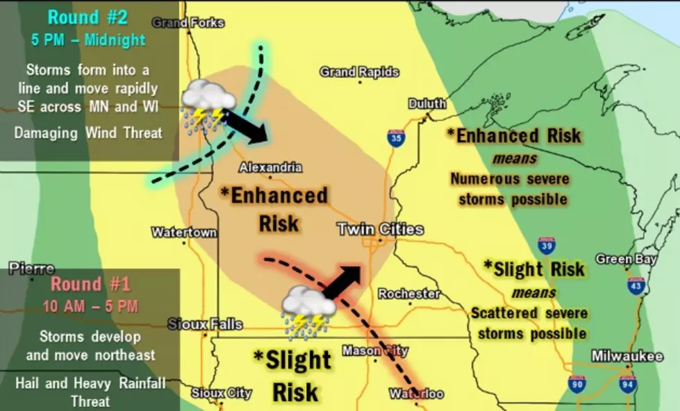
We will see two rounds of storms across the state today with the first coming this morning into the early afternoon across the east, with a second line coming into the west during the
afternoon and pushing east across the state through the evening. It is this second line that will pose a risk for severe weather, in particular with a threat for strong wind gusts.
This second round of storms will develop ahead of a cold front, a cold front that will finally push the oppressively hot and humid air out of the state for Sunday.
We will see dry weather Sunday and Monday, but an active jet pattern over the state will keep chances for showers and thunderstorms going Tuesday through Friday, though temperatures will be much more comfortable than what we have been
experiencing since Wednesday.
More From AM 1240 WJON

![Is Kirk Cousins Finding Out The Grass Isn’t Always Greener? [OPINION]](http://townsquare.media/site/65/files/2021/11/attachment-GettyImages-1350512207.jpg?w=980&q=75)


![Paynesville in Pictures [GALLERY]](http://townsquare.media/site/67/files/2024/04/attachment-Paynesville-Sign.jpg?w=980&q=75)